KES 295,000,000
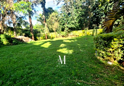
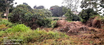
1.25 Acre Garden Plot with Parking - KSh 295M
Nyari, Westlands, Nairobi
2 residential plots available in Nyari, Westlands — prime location near Karura Forest.
KES 295,000,000
Nyari, Westlands, Nairobi
KES 125,000,000
Nyari, Westlands, Nairobi
Nyari is a residential locality in Westlands, Nairobi County, with 2 residential land listings available. The area is accessible via Waiyaki Way and lies near Karura Forest, offering a blend of suburban tranquility and city proximity.
Popular sub-areas within Westlands include Nyari. Browse the listings below to find available plots in Nyari and surrounding neighborhoods.
Nyari is a quiet residential locality within Westlands, Nairobi County, offering a serene environment close to the city's amenities. Currently, there are 2 residential plots for sale in Nyari, with prices ranging from KES 125,000,000 to KES 295,000,000 and a median price of KES 210,000,000. The area is accessible via Waiyaki Way and is near Karura Forest, making it attractive for those seeking a blend of urban convenience and natural surroundings.
Nyari's proximity to Westlands' commercial hubs and Karura Forest provides a unique lifestyle opportunity. The area is primarily residential, with plots suitable for building high-end homes. While inventory is limited, the available listings reflect the premium nature of this locale. For comparison, the broader Westlands area features a mix of high-rise apartments and townhouses, but Nyari remains a low-density enclave.
If you're looking for land in a well-connected, upscale neighborhood near Nairobi's central business district, Nyari merits attention. Browse our listings to find the perfect plot for your needs.
As of today, there are 2 residential plots listed for sale in Nyari, Westlands. The price range for these plots is KES 125M — KES 295M, with a median price of KES 210,000,000.
The median price for residential land in Nyari, Westlands is KES 210,000,000. Prices vary based on plot size and location within Nyari, with the current range spanning KES 125M — KES 295M.
Nyari is a residential locality within Westlands, Nairobi County, situated to the northwest of Nairobi's central business district. It is accessible via Waiyaki Way, a major road connecting Westlands to the city center.
Nyari is in the vicinity of Karura Forest, a large urban forest reserve to the north. Westlands, a major business hub with office towers and shopping centers, is nearby. The area also offers easy access to Waiyaki Way and the A104 highway.
Nyari is primarily a residential area, so the land for sale is zoned for residential use. The plots are suitable for building homes.
To verify land ownership in Nyari, conduct an official search at the Ministry of Lands office in Nairobi or use the Ardhisasa online portal. The search reveals the registered owner, encumbrances, and parcel history.
The price range for residential land in Nyari, Westlands is KES 125M — KES 295M.
Trusted by buyers across Kenya
Verified agents. Transparent listings. Built for the Kenyan market — since 2020.
Market data
Live aggregate. Updated continuously from active listings.
Real people, real expertise
Vetted local experts. No middlemen, no inflated commissions.
What it's like here
Nyari is a residential locality in Westlands, Nairobi, with 2 land listings available. It sits near Karura Forest and is accessible via Waiyaki Way, offering a quiet suburban setting close to the city.
Nyari is accessible via Waiyaki Way (A104), a major road connecting Westlands to Nairobi's CBD. Matatus and ride-hailing services provide public transport options. The CBD is roughly 15-20 minutes by car depending on traffic.
Nyari is near several reputable schools in Westlands and surrounding areas, including Brookhouse School, St. Mary's School, and the International School of Kenya. Public schools in the vicinity serve the local community.
Nyari is a relatively quiet residential area with gated communities and private security. Neighbourhood watch and community policing are active. Proximity to Karura Forest adds a natural buffer.
Residents have access to shopping centres in Westlands, such as Westgate Shopping Mall and Sarit Centre. Healthcare facilities include Aga Khan University Hospital and Nairobi Hospital within a short drive. Karura Forest offers recreational trails and green space.
Local snapshot for Nyari. Verified by Jumuika research; updated periodically.
Expand your search
Quick estimate
Kenyan land purchases carry stamp duty, advocate fees, and registration costs on top of the price. Use this calculator for a quick estimate — figures are illustrative; your advocate will confirm exact charges.
Urban includes Nairobi, Mombasa, Kisumu, and most municipal areas.
That's on top of the purchase price.
Estimates only. Your advocate will confirm exact fees based on your transaction. Not legal or tax advice.
| Area | Price per Acre | 1/8 Acre Plot | YoY Change | Demand |
|---|---|---|---|---|
| Nyari | KES 80-150M | KES 10-18M | +15% | High |
Discover residential land for sale in this serene Nairobi suburb near Karura Forest. Our team is ready to help you secure the perfect property.
10,000+ verified agents across 47 counties.
Typical response: under 2 hours.
Verified service
Worried about title fraud? Our title search service verifies ownership and encumbrances for any plot in Nyari, Westlands. Get a detailed report within 48 hours for a flat fee of KES 5,000. Buy with confidence.
No commitment. Pay only when you proceed.
Zoning and building regulations for residential land in Nyari, Westlands, Nairobi County.
Low-density residential zone with allowance for home businesses, subject to Nairobi County development control rules.
Infrastructure
Utility status varies across Nyari. Confirm availability of electricity, water, and internet before making a purchase decision.
Nyari is accessible via Waiyaki Way, a major all-weather road connecting Westlands to Nairobi's CBD.
Kenya Power supply is available in the area. Connection fees apply.
Nairobi Water and Sewerage Company serves Nyari. Most plots have metered connections.
Reticulated sewer system is available in Nyari, connected to Nairobi's main sewer network.
Safaricom Home Fibre, Faiba, and other ISPs offer high-speed internet. 4G coverage is reliable.
What's coming next
Improved connectivity from Nyari to Nairobi CBD and Westlands, reducing travel time.
Faster access from Westlands to JKIA and Mombasa Road, enhancing Nyari's commuter appeal.
Potential rail link from Nairobi CBD to Westlands, easing daily commutes for Nyari residents.
New office and retail space nearby, increasing demand for residential land in Nyari.
High-speed internet available in Nyari, supporting remote work and property values.
Improved water reliability for Nyari, a key factor for residential development.
How to verify land ownership and avoid fraud when buying land in Kenya.
Always verify title deeds at the Ministry of Lands before making any payment. Never rely solely on documents provided by the seller. Use a licensed lawyer for all transactions.
Absolute ownership of land for an indefinite period. The owner has full rights to use, transfer, and lease the land.
Ownership of land for a specified period, typically 99 or 999 years, after which ownership reverts to the lessor (usually the government).
Ownership of a unit (e.g., apartment) within a multi-unit development, with shared ownership of common areas.
A historical land tenure system in Uganda, but also found in parts of Kenya (e.g., coastal region) where land is held under customary or freehold arrangements.
Before you buy land in Nyari, verify boundaries with a licensed surveyor. The Survey Act (Cap 299) requires all land transactions to be based on an accurate survey to avoid disputes and encroachments.
A proper land survey confirms exact boundaries, size, and ensures no encroachment. In Nyari, where plots border Karura Forest and other prime areas, a survey safeguards your title deed and future development plans.
Establishes the exact boundaries of a plot, marking beacons at each corner. Essential for confirming the land size matches the title deed.
Maps the natural and man-made features of the land, including contours, slopes, drainage, and existing structures.
Subdivides a larger parcel into smaller plots or consolidates multiple plots into one. Produces a new deed plan for each resultant parcel.
Places or replaces physical markers (beacons) at boundary corners as per the registered deed plan. Often done after a perimeter survey.
Listings, prices and market statistics on this page are drawn live from the Jumuika database. Descriptive text is AI-assisted and editorially maintained by the Jumuika team.
Are you a real-estate agent?
Agents apply for verification — sign-up here is for buyers and renters.
Apply for agent accessFind your dream home in Kenya
Already have an account?
We sent a 6-digit code to